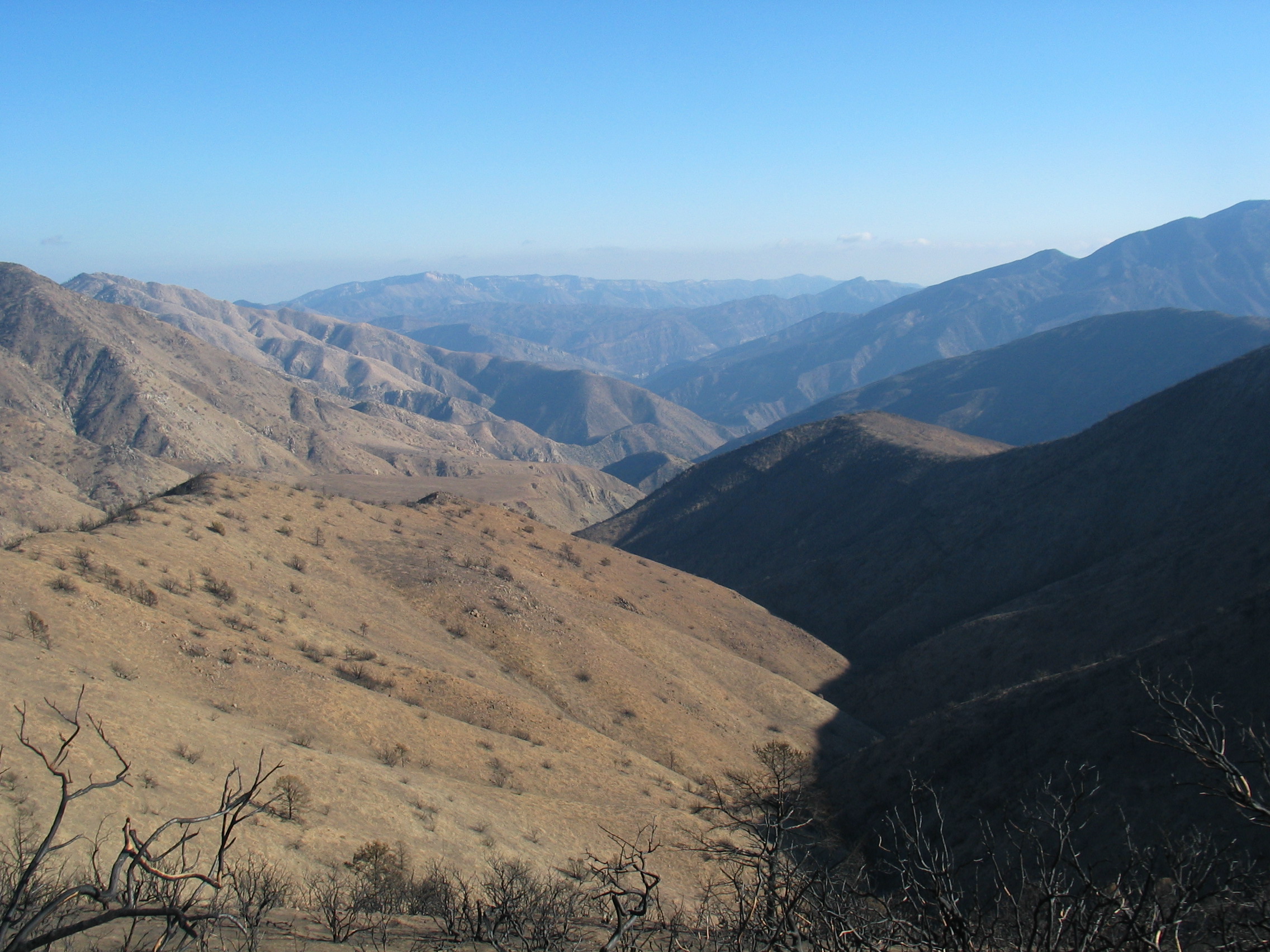
View from the Johnston Ridge Trail
looking east toward the Sespe Hot Springs,
before the Day Fire.
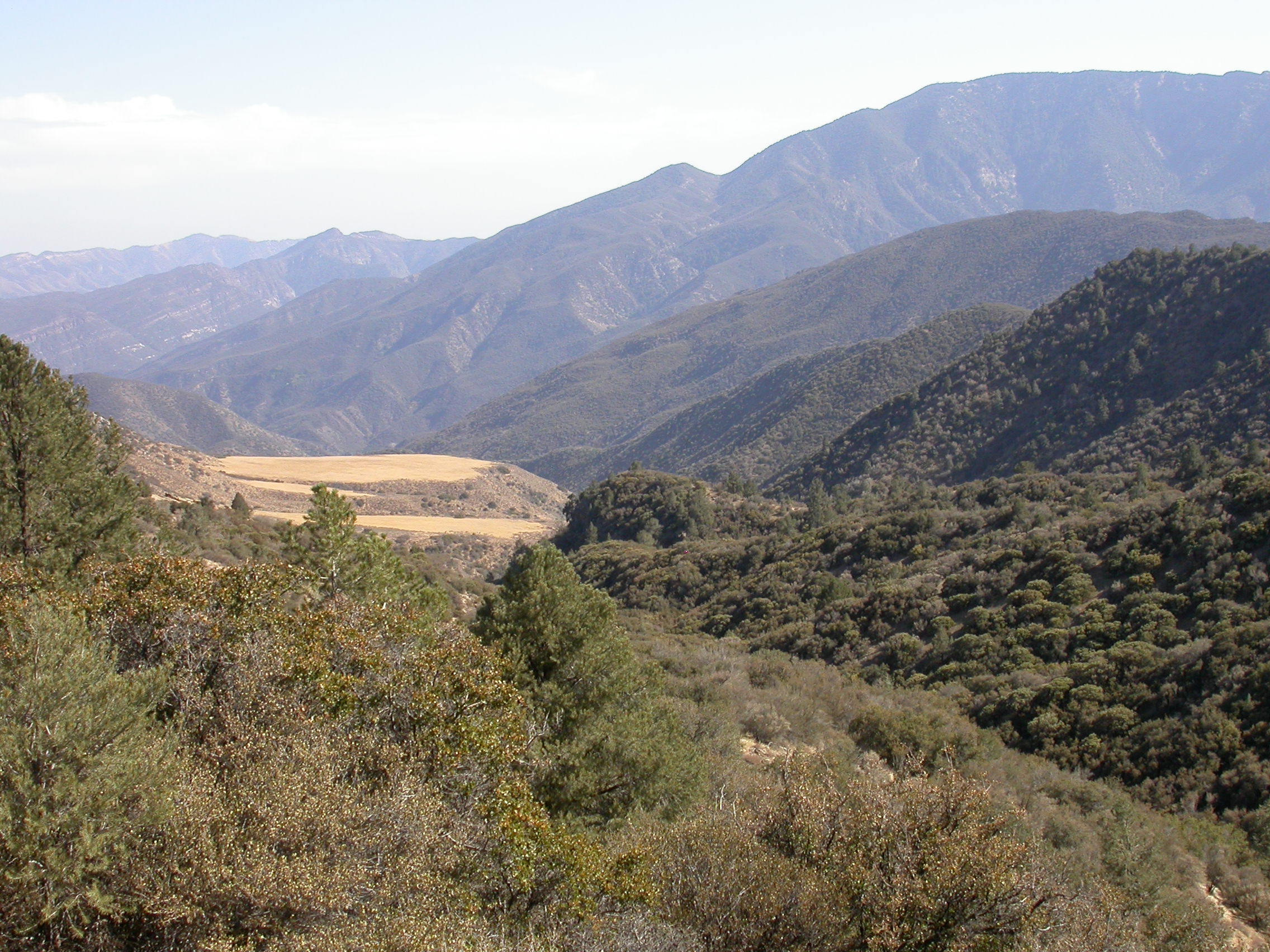
View of the same area, taken from a little further south on the Johnston Ridge Trail, after the Day Fire.
The grassy flat meadows are in about the same place in this photo as they were in the first; a little above center on the left.
After The Day Fire
In mid-November, around 6 weeks after the Day Fire was eventually contained, the US Forest Service produced a Burned Area Emergency Response (BAER) Assessment, a 40-page document from which we selected the following information.
The BAER Assessment is available on the internet at http://www.fs.fed.us/r5/lospadres/fire/incident-info/baer-rpt-final11-06.pdf
40 square miles or 15% of the Sespe’s watershed was estimated to have burned at high or moderate severity during the Day Fire. Another 6%, 16 square miles, burned at low severity.
Most of the Day Fire (77%) burned in adjacent watersheds, those surrounding Piru Creek and Santa Paula Creek.
The risk of erosion of sediment into Sespe Creek from hillsides denuded by fire is high (although the current mild rainfall season will lessen the immediate erosion potential). The BAER Assessment estimates an average loss of 14 tons of sediment per acre into the
Sespe over 2 years, particularly from Hot Springs Canyon and from West Fork Sespe. The Hot Springs Canyon area is estimated to produce 18 times more sediment than usual; West Fork 7 times more.Near the Hot Springs, most of the north facing slopes on the south side of Sespe Creek burned with moderate severity, while the south facing slopes on the north side of the Sespe burned with low severity.
90% of the West Fork Sespe drainage was within the Day Fire perimeter. Of this, 45% suffered moderate burn severity.
Along with sediment, rainfall runoff into Sespe Creek is expected to increase by between one-third and two-thirds of normal.
40 miles of forest road were within the Day Fire perimeter, as were 44 miles of trails. The US Forest Service will not be reseeding the Sespe watershed’s burned area.
Around 55% of the Day Fire area is classified as chaparral, a plant community dominated by artemisia, buckwheat, chamise, manzanita and scrub and live oak. Most of these recover quickly after fire. Some seeds, including ceanothus and manzanita, only germinate after a fire.
4% of the Day Fire area is Big Cone Douglas Fir forest. Mature Douglas Firs sprout vigorously from the branches and trunk after fire.14% is Yellow Pine forest, including Ponderosa and Jeffery Pines. This plant community experienced low to moderate burn severity – meaning that less than 50% of the trees were killed by the fire.
16% of the Day Fire area is Singleleaf Pinyon Pine woodland. This is a climax vegetation type, taking 300 years to reach its climax after a disturbance such as fire. Most of this plant community also experienced low to moderate burn severity, which will result in tree mortality of between 10% and 30%.
Generally, the low shrubs we see across the Sespe’s watershed will recover up to 80% in the first year after the Day Fire. Wildflowers are often in full show in the first and second springtimes after a fire.
164 miles of access and fuelbreak roads were bulldozed during the Day Fire. As well as tearing up the backcountry, these dozer roads can serve as infestation fronts for exotic, invasive weeds, whose seeds were carried in on the heavy equipment used. There was no inspection or washing of equipment on its way to fight the Day Fire, so the impacts remain to be assessed. To see a map of the firelines constructed by hand and by bulldozers during the Day Fire, go to www. sespewild.org
A total of 116 heritage sites are within the Day Fire area, of which 92 are of Native American origin. These include middens, bedrock mortar sites, quarries and toolmaking sites, rock art sites and villages.
Of funds requested for post-fire projects, 21,390 is for noxious weed surveying; $65,327 is for protection against the looting and destruction of archaeological resources; $605,295 will go to road repair; and $343,293 to trail work. $87,305 is allocated for the removal of hazardous trees by roads, for the physical closure of trails and an assessment of tree hazards beside trails. Administration comes to $154,097 and Implementation a further $65,150. The total amount requested was $1,370,467.
BURN AREA CLOSURES
The burned area of the Day Fire in Los Padres Forest remains closed through the rainy season to protect the hiking public from the dangers of trail erosion, hazardous trees and the like.
While we believe that some common sense precautions can minimize any such risks, the closure will be in effect until the US Forest Service opens our forest to us again. We are all keen to explore areas that we may never see burned for many decades to come.
Following is an account of our January 2007 trip to the Sespe Hot Springs, going in from Lockwood Valley, and the changes we found as a result of the Day Fire in the Fall of 2006.
To see a collection of photos taken on this hike down the Johnston Ridge Trail, to the Sespe Hot Springs, please click here.